Part 1 Appraisal
2. Context
This appraisal defines the special interest of the conservation areas that merits its designation and evaluates the contribution made by the various elements of its character and appearance. It outlines the features that make the Webb Estate and Upper Woodcote Village significant, including their wider context such as historical development, setting, townscape, streetscape and architectural character. This section also assesses their current condition and identifies the threats currently facing the conservation areas.
This appraisal is not intended to provide an exhaustive account of the conservation area. The absence of specific reference to a particular building, structure, feature or space should not be taken to imply that it lacks significance.
2.1 Location, topography and setting
2.1.1 The Webb Estate and Upper Woodcote Village are residential conservation areas in South London (Map 3) located to the west of Purley town centre. Purley is situated in the centre of two valleys cut into the chalk surface of the North Downs one running north-west from Caterham (Godstone Road) and one running north-north-east through Coulsdon (Brighton Road). The valley floor lies at 200 ft above sea level and the highest point lies at 400 ft. Purley Station is 0.5 miles away from the conservation area, providing good connections to Central London and Gatwick Airport.
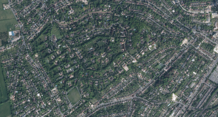
Map 3. Aerial Photograph of the Webb Estate and Upper Woodcote Village - 2024
Brighton Road Local Heritage Area
2.1.2 The Brighton Road and High Street area, situated in close proximity to the Webb Estate, represents a well-preserved collection of shopping parade buildings dating from the late 19th to early 20th century. The quality of architectural detailing and the variety of styles including Victorian, Mock Tudor and Art Deco inspired features create parades of imposing buildings. The area is distinctive and retains the historic pattern of development that still contributes to the setting of the Webb Estate Conservation Area.
Foxley Lane and Banstead Road developments
2.1.3 In 1888, Webb purchased the land which was to become the estate and initiated its development. While preparing the site, he began construction on Banstead Road. The first house he built was Banstead Lodge in 1898, followed by properties on Foxley Lane in 1900 , located outside the estate. Banstead Lodge on 21 Foxley Lane has been converted to Purley Dental Practice today. Webb extended his building programme to the Upper Woodcote Village in 1901 and subsequently to the Webb Estate.
Scakebread archaeological priority area
2.1.4 The estate is not within an Archaeological Priority Area but is close to the Scakebread Archaeological Priority Area (APA), which runs partly along the Sutton/Croydon border and lies within Sutton Borough. This archaeological priority area includes the medieval village of Woodcote, which was part of the Beddington estate established on the Downland plateau. By the 16th century, the village had been abandoned; however, surviving historic farm estates might still contain important residual artefacts of this historic settlement.
2.2 Historic development
2.2.1 The earliest recorded findings in the area include Bronze Age evidence of early man found on Promenade de Verdun. Purley itself hardly existed until the late nineteenth century when it began its transformation from a quiet, agricultural area of Surrey into a vibrant suburb of London. As London's population grew and the urban area expanded, the Borough of Croydon became more urbanised and those who could afford it, chose to build their homes in the less crowded areas including Purley. This shift in population was greatly boosted in 1841 when the first railway arrived in the area, making the suburb a viable living option for those working in London, thus laying the foundations for Webb's vision.
2.2.2 Webb observed that "A few City men live at the West End but by far the greater number seek to spend their leisure time and bring up their families at the nearest spot to their work where they can find a comparatively country home." This insight formed the foundation of his vision for the Webb Estate and Upper Woodcote Village: to create a carefully planned suburban environment that combined the benefits of rural living with convenient access to the city. It was this guiding principle that shaped the design and development of the estate, which was formerly open land (Map 4) that belonged to the historic Beddington Estate.
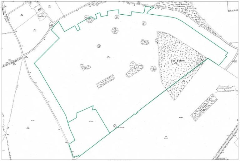
Map 4. Historic map progression – 1890 OS Map
2.2.3 The parish of Purley was created in 1880 as major development began to occur in the form of villa-style housing. The Croydon Municipal Tramways reached Purley in 1901 and at this time many of the villas were starting to be demolished along Brighton Road to make way for rows of shops, securing Purley as a place in its own right rather than simply a commuter village.
2.2.4 Purley Sports Club, founded in 1907 as a cricket and lawn tennis club, is situated to the north of the estate. To the west, Woodcote Park Golf Club borders the Scakebread Archaeological Area, which was also historically part of the Beddington Estate. William Webb was deeply involved in the development of Woodcote Park Golf Club 1912, driven by his enthusiasm for golf. These clubs were developed alongside the estate, offering recreational amenities that complemented the lifestyle envisioned for the working classes living in the area.
2.2.5 Additional amenities were introduced over time, including the Cottage Hospital (established in 1909, later renamed Purley War Memorial Hospital), the Astoria Cinema (opened in 1934, subsequently demolished), and a swimming pool as part of the Purley Leisure Centre (built in 1981). These developments firmly established Purley as one of the most significant district centres in the Borough.
Webb’s vision and the garden city movement
2.26 William Webb (1862-1930) was a chartered surveyor and local estate agent who went on to become a pioneer of the garden estate idea in the UK. He was a visionary and spent his lifetime developing a solely residential suburban estate for city workers in Purley. Webb's aims were idealistic behind his solid philosophy which is clearly set out in his book, Garden First in Land Development (1919) and as the title implies, he took the unusual step of landscaping the site before any building work commenced. His meticulous attention to detail ensured that the entire estate was comprehensively designed and constructed to an incredibly high standard.
2.27 The garden city movement, initiated by Ebenezer Howard in his book, Garden Cities of Tomorrow (1902), is widely recognised as one of the most significant milestones in the history of town planning in the UK. The concept of the garden city achieved popularity by the end of the nineteenth century, aiming to combine the best of country and city living. Garden cities were to be planned, self-contained communities surrounded by greenbelt. They were a reaction to the overcrowded, industrialised towns of the time and offered rural housing estates combined with sufficient arable and industrial land where everyone had easy access to the countryside. Examples of these Garden Cities include Letchworth, which was begun in 1903, Hampstead Garden Suburb, 1905 and Welwyn Garden City, begun in 1920.
2.2.8 William Webb developed the Webb Estate and Upper Woodcote Village specifically as a residential suburb, distinct from Letchworth’s industrial provisions or the communal facilities of Hampstead Garden Suburb. The time for the landscape to establish itself was an essential element in the development of the Webb Estate, setting it apart from other more widely known garden suburbs. Webb’s approach to housing design was not driven by ‘architectural merit, but rather to show how any simple and restrained style of building may be made more attractive by landscaping. As part of this vision, fast-growing climbers were planted so that the houses quickly lost their raw, new look.
2.2.9 His restrictive covenants outlined specific requirements regarding distances from boundaries and the road, as well as various aesthetic considerations. Webb implemented rigorous guidelines for both building construction and landscaping, including a minimum building cost requirement to uphold high standards of craftsmanship across the estate, while also requiring architects to design each elevation with equal attention to ensure all views to the property were attractive.
Establishment of the estate
2.2.10 When building began in 1898, houses were set on predefined plots separated by mature boundary hedges and established planting (Map 5). In 1903, a model village known as Upper Woodcote Village was laid out in the south-western corner of the Estate, centred around a green. Upper Woodcote House, completed in 1903, was the first dwelling on the estate and served as Webb’s own home. Rose Walk was laid out in 1907, followed by the completion of the South Border in 1912. By 1920, Furze Hill, Furze Lane, Woodcote Lane, and Briar Hill had also been developed. By 1925, the initial development was largely complete (Map 6).
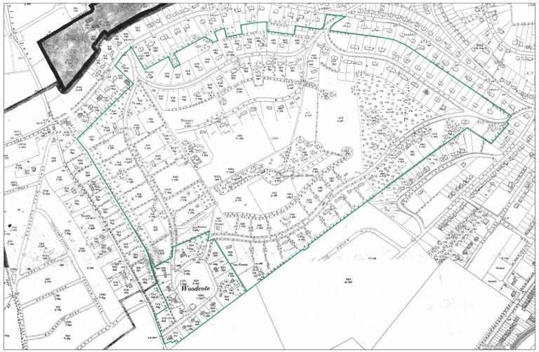
Map 5. Historic map progression – 1910 OS Map
2.2.11 Between 1925 and 1940, a certain amount of infilling has taken place following the estate’s initial development (Map 7). Until the late 1960s, only a few buildings were constructed within the inner estate however these did not compromise the overall secluded character of the conservation area. Map 44 illustrates the approximate ages of the buildings, based on the original core structures preserved within the conservation areas.
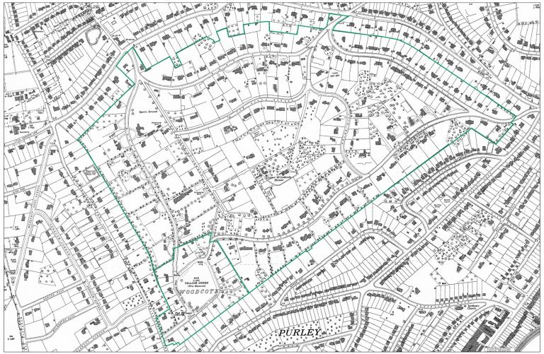
Map 6. Historic map progression – 1933 OS Map
Non-statutory protection
2.2.12 According to Webb, if a complete scheme of development is decided on in detail from the commencement of the scheme, it is likely to lack originality and a personal touch. In contrast, if the development of various roads and areas is gradually planned over several years, incorporating past experiences and lessons learned, it can lead to new and innovative ideas. The development of Garden First should be approached as an art, which allows for creativity and adaptation, rather than as a strict science, which could be rigid and monotonous. Consequently, the approach proved to be experimental, allowing for the emergence of diverse individual styles throughout the estate, characterised by simple yet creative and authentic vernacular architecture. To ensure the integrity of the Estate remained intact, Webb laid out a set of restrictive covenants:
- No house erected on the land shall be used for any purpose other than that of a private residence.
- No house shall be advertised as or designed for or occupied as flats nor shall any trade, business, profession, school or manufacture be carried out on the said piece of land. Nor shall anything be done that shall become a nuisance or annoyance to the adjoining owners.
- No building shall be erected within 60 feet of the road or 10 feet of the side boundaries. No part of the land shall be used as a public road or as a means of access to another property.
- No boundary or party fences or walls shall be erected on the land other than wire fences and live hedges and the Purchaser shall do all that be necessary to maintain such parts of the live hedges as are on his ground.
- The display of contractors advertising boards is not allowed.
- No clothes, except children's garments shall be hung out to dry unless hidden by a hedge or other suitable enclosure.
2.2.13 Although the latter two may need to be adapted to fit in with modern life on the Estate, the covenants continue to play an important role in the preservation of the character of the Webb Estate and Upper Woodcote Village and the most important ones have been incorporated into this document as guidelines for new development.
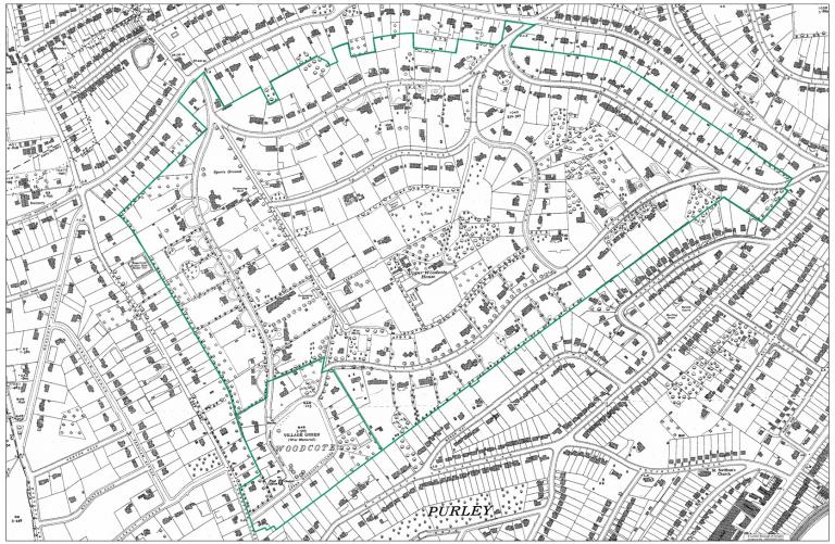
Map 7. Historic map progression – 1940 OS Map
