Appraisal
1. Introduction
1.1 What is a Conservation Area
Conservation areas are areas of special architectural or historic interest, the character and appearance of which it is desirable to preserve or enhance. Conservation areas were introduced in 1967 and there are now nearly 10,000 in England. They are designated under the provisions of Section 69 of the Planning (Listed Buildings and Conservation Areas) Act 1990. Local authorities have a statutory duty to identify areas that fulfil these criteria, to designate them as conservation areas, and to review these designations from time to time. Conservation areas are classified as ‘designated heritage assets’ in the National Planning Policy Framework (NPPF).
1.2 What is a Conservation Area Appraisal and Management Plan
1.2.1 A Conservation Area Appraisal and Management Plan (CAAMP) is a document produced to supplement the London Plan, Croydon's Local Plan, and Croydon's Conservation Area General Guidance Supplementary Planning Document (SPD).
1.2.2 This document comprises two parts: Part I: Appraisal, which sets out the conservation areas’ special interest, highlighting those elements which contribute to or detract from their special interest; and Part II: Management Plan, setting out the Council’s strategy for managing change in the conservation areas to ensure that their character is preserved and enhanced.
1.2.3 This document comprises two parts: Part I: Appraisal, which sets out the conservation areas’ special interest, highlighting those elements which contribute to or detract from their special interest; and Part II: Management Plan, setting out the Council’s strategy for managing change in the conservation areas to ensure that their character is preserved and enhanced.
1.2.4 The methodology for this appraisal and management plan follows the best practice guidance set out in Historic England’s Historic Environment Advice Note 1: Conservation Area Appraisal, Designation and Management | Historic England (2019
1.3 Conservation and community involvement
1.3.1 Early engagement was undertaken when this document was being drafted with key stakeholders, conservation area advisory committee, and local community groups.
1.3.2 The Council engaged with the Webb Estate Residents’ Association, Purley and Woodcote Residents' Association and the South Croydon Conservation Area Advisory Panel in producing this draft document. Initial consultation was carried out with the Webb Estate Residents’ Association and the South Croydon Conservation Area Advisory Panel through a Walk and Talk Tour. During the tour, participants engaged in an exercise to share thoughts and concerns about the area. The feedback gathered from this event was used to inform a draft Conservation Area Appraisal and Management Plan prior to formal public consultation.
1.3.3 Public consultation was undertaken between [consultation info]. The draft document has been published for a 6-week public consultation from [date] to [date]. The public is invited to review and comment on the new document, which will be amended following the consultation having regard to comments received
1.4 Designation background
1.4.1 The London Borough of Croydon has 21 conservation areas. Upper Woodcote Village was designated as a conservation area in November 1973 and the Webb Estate in 1983 with the exception of Furze Lane. The Webb Estate Conservation Area was expanded to include Furze Lane in 1984 after a residents’ petition. A Proposal Statement for the conservation areas was first published in 1984.
1.4.2 In 2007, as part of the boundary review and update, the Conservation Area was extended to incorporate the lodge bungalows that were previously outside its limits. These bungalows hold significant historical and architectural value, contributing to the area's unique character.
1.4.3 As a result of this extension, the Webb Estate Conservation Area was expanded to include Rose Cottage (119 Foxley Lane), Gate Lodge (Woodcote Lane), and Christmas Cottage (47 Furze Lane), along with the entire lengths of Furze Lane and Furze Hill. Similarly, the 2007 boundary update for the Upper Woodcote Village Conservation Area incorporated Gate Lodge (1 Upper Woodcote Village), 1A Upper Woodcote Village, 20 Upper Woodcote Village, and 21 Upper Woodcote Village, acknowledging their significance as part of Webb's original village road landscaping scheme.
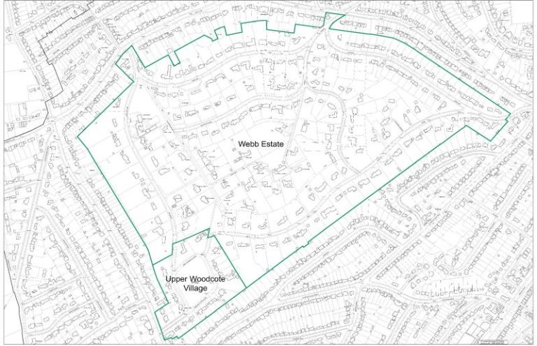
1.4.4 This updated document does not propose any changes to the existing boundary (Map 1) and will supersede the current Conservation Area Appraisal and Management Plan Supplementary Planning Document adopted on 25 June 2007.

Map 1. Webb Estate and Upper Woodcote Village Conservation Areas boundary map
1.5 Statement of special character
1.5.1 The area covered by the Webb Estate and Upper Woodcote Village Conservation Areas is a planned residential estate developed in the early 20th century by William Webb, putting into practice the idealistic principles set out in his book ‘Garden First in Land Development’. Webb sought to create a garden village in the suburbs, within easy commuting distance of London, offering an attractive and healthy lifestyle for city workers. Purley, then a small village on the outskirts of London, was deliberately chosen for its strong transport connections and semi-rural character.
1.5.2 Much of the area’s special interest derives from the distinctive landscape character, where the original houses of the estate are thoughtfully integrated into the streetscape. The authenticity of the conservation areas lies in the seamless integration of diverse architectural styles with the organically designed landscape. This is further enhanced by the picturesque quality of the streets, defined by specimen trees and abundant greenery of exceptional scenic value. The estate is very well-preserved, with most of the original layout, landscaping, and buildings remaining intact.
1.5.3 The key features that make a positive contribution to the special interest of the area are as follows:
- The conservation areas are of particular significance in the context of the UK’s town planning and landscape design history. They represent one of the earliest examples of a garden village, largely preserved through the implementation of restrictive covenants that reflect William Webb’s pioneering ‘garden first’ principles.
- The landscape and layout are unique, as the conservation areas were laid out and planted well before construction began, retaining the established landscape and allowing it to mature. The verdant character of the Estate is defined by mature landscaping, particularly specimen trees and biodiverse planting, which contribute to the distinct identity of each street, also echoed in the street names. Low-density development, a strong sense of openness and permeability, and limited inter-visibility between buildings are key characteristics of its layout.
- The conservation areas are unique within the borough, where most others feature development from a range of historical periods. In contrast, the Webb Estate and Upper Woodcote Village were purpose-built in a short period of time from 1903 to 1925, resulting in a cohesive yet architecturally diverse built environment.
- The Estate’s unique character within the borough is defined by its relatively secluded tranquillity, achieved through an inward-facing suburban layout and perimeter through-routes that separate the conservation areas from the surrounding townscape.
1.6 Character Areas
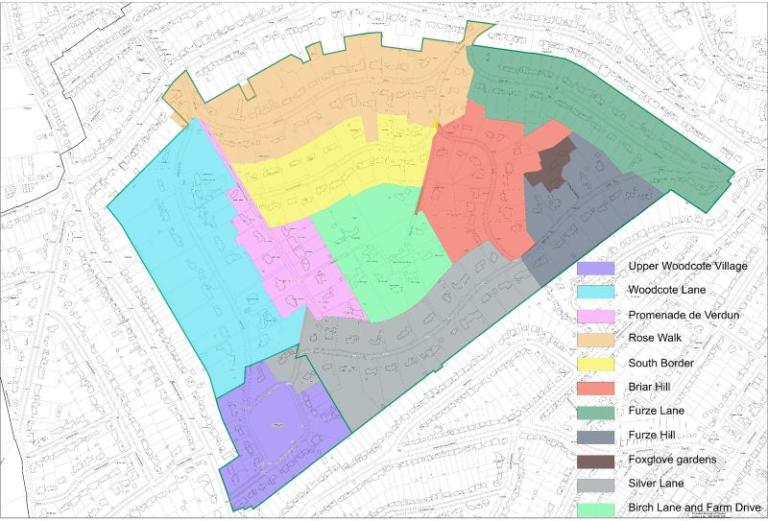
The combined conservation areas contain ten distinct Character Areas. These are shown Character Areas Map (Map 2).
Furze Hill: Steeply sloping topography with landscaped banks lining the road. Houses set well back from the road in large plots, screened by tall hedges. Topography allows for some wide-ranging views beyond the estate.
Foxglove Gardens: One of the most recently developed streets, designed as a cul-de-sac that services three detached houses.
Furze Lane: One of the earlier streets developed. Characterised by mainly semi-detached houses in smaller plots.
Silver Lane: Verges lined with silver birch trees and a variety of spring bulbs.
Briar Hill: Generally detached houses with tall hedging and planting.
Birch Lane and Farm Drive: Originally provided access to Upper Woodcote House (Webb’s own home), these streets are much smaller in scale and resemble country lanes.
Rose Walk: One of the grandest streets with a formal character and large detached houses addressing the street. Verges were originally planted with roses.
The South Border: A wide street laid out in a sweeping curve with a formal character and large houses. The street is lined with decorative planted borders.
Promenade de Verdun: Narrow and completely straight, lined with poplars and terminated by the First World War Memorial – the promenade was designed as a memorial landscape.
Woodcote Lane: Generally flat and shady street of detached houses screened by tall hedges.
Upper Woodcote Village: Cottages arranged as semi-detached houses around a green – this was the first part of the estate to be developed and was originally intended as workers’ housing.

Map 2. Character Areas Map
